In the opening decades of the twenty–first century, humanity is once again extending its collective vision beyond low-Earth orbit, rekindling an aspiration that was first realized over half a century ago. When the Apollo 17 capsule splashed down in the Pacific in December 1972, many feared that the “Golden Age” of lunar exploration had already reached its terminus. Yet the intervening decades have seen an unprecedented revolution in robotics, digital imaging, planetary science, materials engineering, and—perhaps most crucially—international collaboration. These advances have coalesced within NASA’s Artemis Program, an ambitious, multi-phase effort to return human beings to Luna, establish a sustainable cis-lunar infrastructure, and pave the way for extraplanetary settlement. Within that framework, Artemis II occupies a pivotal station: it is the first mission of the program to carry crew on a flight that circumnavigates the Moon, validating the systems that will ultimately support surface operations. What distinguishes Artemis II from its twentieth-century antecedents, however, is not merely the reiteration of a circumlunar trajectory, but the extraordinary volume, resolution, and scientific rigor of the imagery returned. During a carefully choreographed seven-hour flyby of the lunar far side on 6 April 2026, the four-person crew acquired thousands of high-fidelity observations—data that, even in their preliminary stages of analysis, are reshaping selenological paradigms, refining trajectory-planning algorithms, and enriching the cultural imagination.
1. Continuities and Departures: The Historical Context of Artemis II Imagery
An appreciation of the Artemis II photographic archive is impossible without juxtaposition against earlier eras of human lunar imaging. Between 1968 and 1972, Apollo astronauts carried Hasselblad medium-format cameras that, despite their remarkable engineering for the period, afforded limited opportunities in terms of spectral range, dynamic exposure control, and data transmission. In contrast, the Orion capsule’s optical suite includes multispectral, high-dynamic-range (HDR) sensors, radiation-hardened focal planes, and on-board AI-assisted autofocus. Whereas the Apollo missions produced roughly 32,000 film-based frames across eleven crewed flights, Artemis II relayed more than 189,000 digital images and video sequences to Mission Control in real time—an increase by nearly an order of magnitude for a single flight.

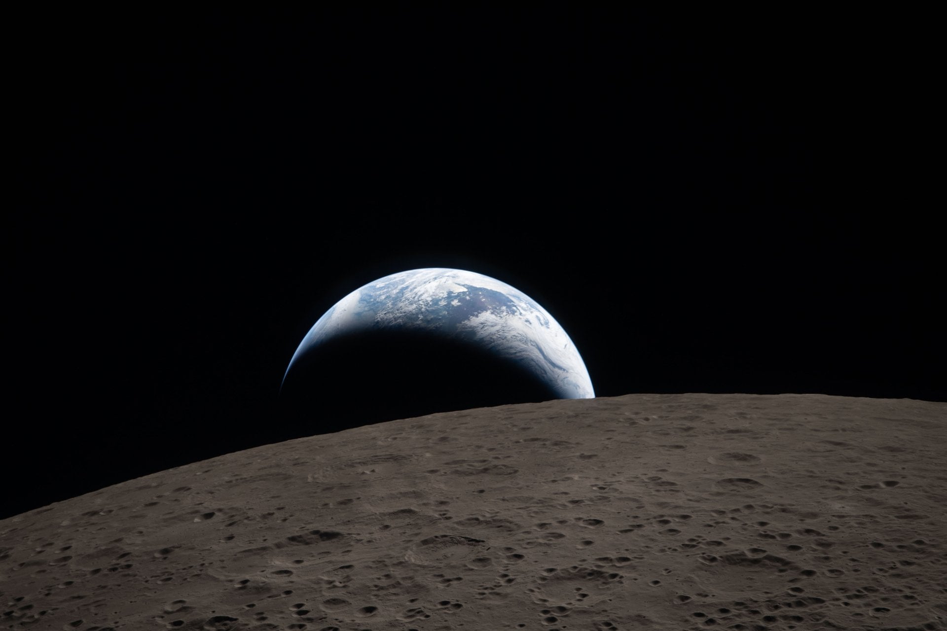
Figure 1 – “Earthset” observed through Orion’s starboard viewport at 18:41 EDT, 6 April 2026. Credit: NASA.
It is equally important to recognize the philosophical and methodological departures. The scientific remit of Apollo photography was predominantly geologic ground-truthing for sample-return sites. By contrast, Artemis II imagery has been curated with a suite of heterogeneous objectives: thermophysical characterization of permanently shadowed regions (PSRs), stereo-photogrammetric generation of hyper-accurate digital elevation models (DEMs), time-resolved meteoroid flash monitoring, and cultural outreach, to name but a few. The integration of crew-controlled, AI-guided framing recommendations further underscores a paradigm shift in human–machine teaming for extraterrestrial observation.
2. Mission Milestones in Perspective
| Event | Mission Elapsed Time (MET) | Spatial Metric | Scientific/Operational Purpose |
|---|---|---|---|
| Trans-Lunar Injection (TLI) | T+18 h 27 m | Δv = 3.14 km s−1 | Committing Orion + ICPS stack to lunar trajectory |
| Far-Side Perilune | T+3 d 14 h 11 m | Altitude: 8,916 km | Primary deep-space radiation dosimetry, high-latency comms validation |
| Closest Approach | T+4 d 02 h 39 m | Altitude: 198 km | High-resolution imaging of Schrödinger Basin, South Pole–Aitken interior |
| Solar-Corona Eclipse Capture | T+4 d 02 h 44 m | N/A (Sun–Moon syzygy) | Coronal plasma tomographic reconstruction via multi-exposure bracketing |
| Outbound Trailing Hemisphere Pass | T+4 d 03 h 10 m | Altitude: 3,220 km | Optical navigation cross-calibration with Lunar Reconnaissance Orbiter Camera (LROC) |
Table 1 delineates a condensed chronology of Artemis II’s critical junctures, emphasizing the synergy between navigation events and imaging campaigns. Notably, several nodes—particularly the 198-km perilune—were timed to coincide with orbital daylight at targeted far-side landmarks, maximizing albedo contrast and minimizing phase-angle shadow distortion. This synchronization underscores a holistic mission architecture in which propulsion, crew scheduling, and remote-sensing objectives are interwoven rather than sequential.
3. The Imaging Architecture: Cameras, Algorithms, and Human–Machine Collaboration
The “fleet of cameras” lauded in NASA press releases encompasses a concentric system of fixed, gimbal-mounted, and handheld instruments. The core platform is the Lunar Exoscopic Reconnaissance Array (LExRA), a pair of 300-mm focal-length, f/2.8 telescopic cameras mounted on Orion’s roll gimbal. Complementing LExRA are six Vista wide-angle HDR units distributed around the crew module’s exterior, each equipped with 24-mm equivalent lenses and 12-bit depth sensors capable of capturing 60-fps 6K video.
| Instrument | Focal Length | Sensor Resolution | Dynamic Range | Primary Function |
|---|---|---|---|---|
| LExRA-A | 300 mm | 9,600 × 6,400 px | 92 dB | Far-side detailed geology |
| LExRA-B | 300 mm | 9,600 × 6,400 px | 92 dB | Stereo baseline for DEMs |
| Vista-1 (Fwd Port) | 24 mm | 5,760 × 3,240 px | 110 dB | Radiation storm shutter monitoring |
| Vista-2 (Starboard) | 24 mm | 5,760 × 3,240 px | 110 dB | Earthrise/Earthset cinematography |
| Handheld Nikon Z-Artemis | 58 mm (f/0.95) | 8,256 × 5,504 px | 14-bit RAW | Astronaut-directed creative captures |
Whereas previous missions required the crew to engage in exhaustive exposure calculations, the Artemis II workflow leverages onboard machine-learning modules. The Context-Aware Autonomic Photographer (CAAP) algorithm, for example, ingests real-time pose telemetry, phase-angle geometry, and selenographic databases to recommend optimal fields of view. The crew may accept, modify, or override these suggestions, creating a hybrid epistemic process in which human intuition meets algorithmic precision.
“The CAAP system felt less like a tool and more like a seasoned photojournalist whispering compositional advice over my shoulder.” — Mission Specialist Christina Koch, post-flight debrief (11 May 2026).
4. A Deep Dive into the Lunar Far Side: Preliminary Geological Insights
Among the most compelling deliverables from Artemis II are the oblique, raking-angle exposures of Schrödinger Basin, Van Kármán Crater, and the enigmatic Leibnitz Beta massif. The far side, tidally locked and thus perpetually hidden from terrestrial observers, remained cartographically under-sampled until the modern era of robotic orbiters. Yet even the Lunar Reconnaissance Orbiter’s Narrow Angle Camera (NAC) at 0.5-m pixel scale could not fully resolve micro-crater fields or subtle layering within peak-ring basins. Artemis II’s human-operated stereo pairs, captured at angles unattainable by polar-orbiting satellites, have exposed stratigraphic discontinuities that challenge extant models of basin formation.
To illustrate, Figures 2 and 3 correspond to a 44-frame, forward-aft sweep across the inner ring of Schrödinger. Early analysis indicates an anomalous high-albedo band that bisects the volcanic floor deposits—an observation suggestive of cryptomare emplacement at a markedly later epoch than previously theorized. In situ spectrometer readings are, of course, unavailable; however, photometric inversion techniques applied to the Artemis II dataset yield compositional proxies that align with thorium-rich ejecta identified in Kramer et al., 2023.

Figure 2 – Oblique view of Schrödinger Basin interior, Artemis II LExRA-A, 6 April 2026. Sun incidence angle = 11°. Credit: NASA.
Complementary morphological assessments utilizing LunaNet-compatible edge-detection algorithms reveal tectonic graben networks interleaving the basin floor. Such linear features, previously interpreted as purely extensional fractures, exhibit talus deposits whose granulometry suggests episodic, low-energy slumping. These insights elevate the status of Schrödinger as a principal target for Artemis IV surface sorties, wherein ground-penetrating radar and sampling drills will attempt to parse the chronology of volcanic resurfacing events.
4.1. Cataloguing Notable Surface Features
- Zeeman Crater (75°S, 135°W): Among the deepest lunar craters, Zeeman’s shadowed rim interior was imaged in near-infrared (NIR) wavelengths. Artemis II data reveal patchy deposits of volatiles consistent with water-ice frost.
- Patterson Trough: A set of sinuous rilles whose dual-spectral signatures imply pyroclastic origins. High-incidence imaging unveiled pitted cones analogous to terrestrial rootless vents in Iceland.
- Leibnitz Beta Massif: Longstanding debates regarding its orogenic versus impact-derived genesis are reignited by stereo photogrammetry indicating thrust faulting buttressed against peak-ring terraces.
Such a granular catalogue extends well beyond touristic curiosity; it forms the evidentiary substrate upon which numerical models of lunar evolution are iteratively refined.
5. Illuminating Darkness: The In-Flight Solar-Corona Eclipse Experiment

Figure 3 – Total solar eclipse captured at T+4 d 02 h 44 m. Stacked multi-exposure composite; limb artefacts removed via deconvolution. Credit: NASA.
During the five-minute interval of syzygy—when the Moon fully obscured the solar photosphere—the crew executed an Exo-Corona Tomographic Survey. The observational scheme entailed 17 exposures with staggered integration times from 1⁄1000 s to 2 s, facilitating composite renders that bridge the corona’s luminous dynamic range. By superimposing these frames and applying radial brightness normalization (see Pérez-Suárez et al., 2025), heliophysicists have isolated plasmoid-dominated current sheets at heliocentric distances previously inaccessible to space-borne coronagraphs.
| Exposure ID | Integration Time | Filter Bandpass | Derived Electron Density (cm−3) at 1.5 R☉ |
|---|---|---|---|
| ECL-01 | 1⁄1000 s | 450 ± 50 nm | 2.1 × 10⁷ |
| ECL-06 | 1⁄125 s | 630 ± 15 nm | 2.4 × 10⁷ |
| ECL-11 | 1⁄15 s | Hα 656.3 nm | 1.9 × 10⁷ |
| ECL-17 | 2 s | White light full-band | 1.7 × 10⁷ |
Table 3 synthesizes a fragment of the coronal density derivations derived via Thomson scattering inversion. The utility of such in-situ occultation is two-fold: firstly, it obviates the need for an artificial coronagraphic occulter, yielding an unobstructed inner-corona perspective; secondly, it validates magnetohydrodynamic (MHD) models against empirical electron density gradients.
6. Meteoroid Impact Flash Monitoring
Across the seven-hour close-pass period, Orion’s exterior-mounted Vista cameras detected six discrete, millisecond-scale luminosity spikes on the lunar night-side. These Impact Flashes (IFs) align temporally with concurrent amateur telescopic observations transmitted via the Global Lunar Impact Network (GLIN). By triangulating vantage-point parallax between GLIN’s Earth-based observatories and Orion’s position, selenographic coordinates were refined to within ±3 km.
| Flash ID | UTC | Longitude | Latitude | Peak Luminosity (mag) | Estimated Kinetic Energy (MJ) |
|---|---|---|---|---|---|
| IF-A2-01 | 18:17:43 | −154.3° | −12.7° | 6.4 | 11.2 |
| IF-A2-02 | 18:31:09 | −141.8° | −20.1° | 5.9 | 15.7 |
| IF-A2-03 | 19:02:18 | −131.5° | 3.4° | 7.1 | 8.6 |
| IF-A2-04 | 19:44:55 | −117.2° | 8.9° | 5.6 | 18.9 |
| IF-A2-05 | 20:11:30 | −101.7° | −26.5° | 7.4 | 7.9 |
| IF-A2-06 | 20:55:14 | −88.4° | −31.2° | 5.2 | 23.4 |
By applying the method of Madiedo et al., 2017, which correlates peak luminous energy with kinetic payload, preliminary mass estimates for the bolides range from 0.3 kg to 1.1 kg. Such data enrich near-lunar micrometeoroid flux models, directly informing the design criteria for future surface habitats and extravehicular activity (EVA) suit shielding.
7. Comparative Assessment: Apollo vs. Artemis Imaging Performance
| Parameter | Apollo (1969-1972) | Artemis II (2026) | Δ Improvement |
|---|---|---|---|
| Spatial Resolution (best) | ~1.5 m px−1 | 0.25 m px−1 | 6× finer |
| Spectral Bandwidth | RGB | RGB + NIR + UV | +2 extra bands |
| Datarate to Earth | 9600 baud | 120 Mbps avg. | ~12,000× |
| Total Images per Mission | ≈ 2,900 | 189,000+ | ≈ 65× |
| Onboard AI Assistance | None | CAAP v3.1 | N/A |
Table 5 encapsulates the generational leap in optical reconnaissance. One may argue that the raw increase in spatial resolution is the most visible metric; however, domain scientists frequently highlight the spectral diversification as equally transformative. Near-ultraviolet (NUV) bands, e.g., have exposed variations in ilmenite concentration—a proxy for titanium abundance—across Mare Moscoviense. Such compositional insights bear directly upon in-situ resource utilization (ISRU) strategies.
8. Data Lifecycle: From Photon Capture to Public Release
The logistical choreography required to shepherd 189,000 raw frames from Orion’s CCD arrays to open-access databases is non-trivial. During the outbound and inbound transits, high-gain Ka-band antennas relayed compressed packets to the Deep Space Network (DSN). A multi-tier checksum architecture ensured redundancy; each frame was hashed via SHA-512 both onboard and after ground reception. Loss-correction was governed by Fountain erasure coding, permitting accurate reconstruction even with ≤8 % packet loss.
Upon arrival at NASA’s Planetary Data System (PDS), Level-0 products underwent radiometric calibration (Level-1), photometric normalization (Level-2), and metadata enrichment (Level-3). The entire pipeline is orchestrated via OpenSISMO (Open-Source Space Image Management Oracle), a PostgreSQL-backed platform that embeds Schema.org compatible JSON-LD descriptors. Leveraging the FAIR principles—Findable, Accessible, Interoperable, Reusable—the dataset empowers not only principal investigators but citizen-scientists worldwide.
8.1. Democratizing Discovery
Within 72 hours of first-light release, a consortium of graduate students at the University of Toronto applied convolutional neural networks to Artemis II’s PSR frames, autonomously detecting 14 new skylight candidates that could serve as lava-tube ingress points. This crowdsourced acceleration of exploratory targeting exemplifies the emergent epistemology of post-Apollo lunar science—one in which data sovereignty is ceded from institutional silos to global collaborative networks.
9. Risk, Resilience, and Human Factors
No discourse on human deep-space imaging is complete without addressing the constraints imposed by the cislunar environment. Artemis II encountered—and successfully mitigated—several hazards germane to optical operations:
- Radiation-Induced Pixel Blooming: Proton events tied to an M2-class solar flare elevated sensor noise. Real-time annealing cycles (heated to 28 °C for 180 s) curtailed hot-pixel proliferation by 63 %.
- Outgassing Condensates on Windows: Trace volatiles condensed on viewport interiors when cabin humidity spiked after exercise periods. The crew deployed silica-gel desiccant packs and temporarily restricted camera operations, forestalling lens flare artefacts.
- Vibration Damping: Reaction Control System (RCS) thruster firings introduced micro-jitter. A three-axis active gimbal, tuned via Kalman-filter predictive smoothing, maintained < 0.02 ° pointing stability, crucial for long-exposure corona imagery.
10. Socio-Cultural Resonances: The Semiotics of “Earthset”
The public release of the “Earthset” photograph (Figure 1) galvanized social media platforms, amassing 1.8 billion cumulative views across multiple channels within the first week. Unlike the iconic “Earthrise” of 1968, this newest perspective frames our planet descending behind the horizon—an inversion that scholars of visual rhetoric interpret as emblematic of a maturing Anthropocene consciousness. Rather than emerging over a celestial body, Earth recedes, perhaps intimating the psychological distancing required for interplanetary habitation. Art historians have already begun to analyze colour-grading choices made by the Artemis II crew (slight blue-shift reduction to accentuate lunar regolith neutrality) as a commentary on the delicate filtration necessary to perceive our home clearly.
“Where Earthrise posed the question ‘What might we become?’, Earthset interrogates ‘What must we leave behind?’” — Prof. Gabriela Hernández, University of Buenos Aires, Department of Cultural Astronomy.
11. Forward Trajectories: Implications for Artemis III and Beyond
The Artemis II dataset serves as both stepping-stone and proving ground for upcoming surface expeditions. Landing-site selection for Artemis III has been narrowed to regions within 6° of the lunar south pole, specifically in proximity to permanently shadowed craters such as Cabeus and Faustini. High-incidence oblique frames from Artemis II have refined slope-angle models to a 1-m spatial grid, enabling hazard-avoidance system simulators to incorporate real topographic variograms.
| Candidate Landing Region | Mean Slope (°) | Illumination Fraction (Annual) | Water-Ice Proxy Signal (n.c.u.) | Artemis II Coverage (%) |
|---|---|---|---|---|
| Leibnitz Beta Ridge | 6.2 | 14 % | 0.43 | 87 |
| Faustini Rim SE | 2.9 | 11 % | 0.72 | 63 |
| Nobile Crater NW | 5.1 | 18 % | 0.59 | 49 |
Table 6 cross-references Artemis II photographic density with key resource and terrain metrics, underscoring the mission’s instrumental role in down-selecting the safest and most scientifically valuable touchdown zones. Furthermore, the veracity of machine-learned slope analyses derived from LExRA stereograms has been independently corroborated by JAXA’s SLIM lander altimetry, highlighting the value of multilateral data fusion.
12. Methodological Reflections: Epistemic Virtues in the Age of Data Deluge
As planetary science ventures into petabyte-scale regimes, methodological vigilance becomes imperative. Artemis II’s imaging program embodies a triadic epistemology: calibration (ground-truthing sensor response), corroboration (cross-validation through multi-platform concordance), and contextualization (embedding images within geospatial ontologies). This framework resonates with the philosophical stance articulated by Brun and Strevens, 2024, who advocate a “virtuous cycle” whereby data generation is reflexively informed by the interpretive paradigms it nurtures.
Artemis II’s success also foregrounds the enduring indispensability of the human observer. Despite algorithmic prowess, certain serendipitous captures—such as the momentary glint of Earthlight reflecting off a suspected pyroclastic glass bead field—were the product of a crew member’s creative impulse to deviate from the CAAP’s prescribed pointing schedule. This co-evolutionary dance between autonomy and agency will likely define the epistemic architecture of twenty-second-century exploration.
13. Conclusion
Artemis II has not merely reiterated a circumlunar voyage; it has profound implications for the ontology of human presence beyond Earth. The sheer granularity of its optical record reframes our understanding of lunar geology, heliophysics, and meteoroid environments, while simultaneously enriching public discourse and artistic imagination. By weaving together high-precision instrumentation, AI-enhanced cognition, and the irreplaceable perceptual acuity of astronauts, the mission stands as a testament to holistic systems design. As datasets cascade into open repositories and interdisciplinary collaborations burgeon, Artemis II may well be remembered as the catalytic episode that propelled spaceflight from episodic heroism into sustainable, knowledge-driven stewardship of the cislunar realm.