Re-evaluating Martian Paleo-Oceanography: From Elusive “Bathtub Rings” to Vast Continental Shelves
Abstract: Since the Viking missions of the 1970s, a central puzzle of planetary science has been the question of whether Mars once possessed an integrated, long-lived ocean in its northern lowlands. Traditional searches have focused on a putative, nearly level “bathtub ring” shoreline. However, recent high-resolution topographic, sedimentologic, and spectral datasets—combined with sophisticated numerical models—indicate that researchers may have been looking for the wrong geomorphic signal. Instead of a simple static shoreline, the Caltech Shelf Hypothesis articulates that the most diagnostic remnant of an ancient Martian ocean is a broad, low-gradient continental shelf analogous to those blanketed by modern terrestrial seas. The present essay offers an exhaustive, interdisciplinary synthesis of the observational, experimental, and theoretical evidence supporting this hypothesis. Drawing on morphometric analyses, comparative planetology, climate modeling, rover-scale petrography, and laboratory flume experiments, the discussion also interrogates counterarguments, explores implications for astrobiology, and maps future mission trajectories. The weight of evidence increasingly favors a scenario in which Noachian–Hesperian Mars hosted a dynamic, but ultimately stable, ocean spanning up to 10.2 × 10⁶ km2. This ocean experienced repeated high-amplitude fluctuations, left a partly buried continental shelf, and established sedimentary environments that may have nurtured early microbial life.
I. Historical Context: The Evolution of the Martian Ocean Debate
The intellectual genealogy of the Martian ocean hypothesis traverses more than four decades of space exploration. Mariner 9 first hinted at lowland floodplains in 1971. The twin Viking Orbiters later identified possible coastal features and enormous outflow channels issuing from chaos terrains. Subsequent missions—Mars Global Surveyor, 2001 Mars Odyssey, Mars Express, MRO, MSL Curiosity, Tianwen-1, and MAVEN—have supplied a near-continuous cascade of higher-quality data. Each new dataset has sharpened constraints on paleotopography, mineralogy, and volatile escape, while simultaneously exposing deeper layers of complexity.
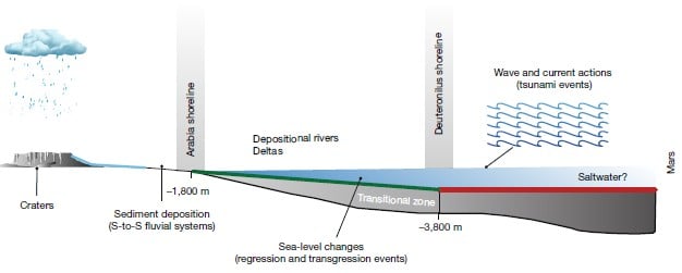
Throughout this time, the “bathtub ring paradigm” maintained a gravitational pull on the scientific imagination. Early shoreline candidates—such as the Arabia and Deuteronilus contacts—bounded the northern plains at quasi-uniform elevations and were mapped by contouring Viking and MOLA topography. Yet those contacts stubbornly diverged from a single equipotential surface by up to three kilometers. Explanatory hypotheses included True Polar Wander (TPW), lithospheric loading by the Tharsis Rise, and visco-elastic relaxation of an early, warmer crust. None of these mechanisms, alone or in combination, reconciled all observed deviations. Consequently, a dialectic tension arose: proponents argued that shoreline distortion is an expected outcome of any real planetary evolution, whereas skeptics pointed to the absence of unequivocal coastal morphologies—wave-cut terraces, tidal rhythmites, beach ridge systems—as fatal defects.
Into this impasse stepped Abdallah Zaki and Michael P. Lamb, whose 2026 Nature paper reframed the problem. By harnessing global slope statistics and hydro-isostatic analogs from Earth, they concluded that researchers had systematically underappreciated the geomorphic prominence of continental shelves relative to cliffed shorelines. Using a “slope break algorithm,” they delineated a circum-boreal, low-gradient surface ranging roughly from –1.8 km to –3.8 km areoid. That surface, not the distorted Arabia–Deuteronilus contact, now appears to encode the primary topographic memory of an ancient ocean.

Table 1. Milestones in the Martian Ocean Controversy
| Year | Mission / Study | Key Contribution | Implication for Ocean Hypothesis |
|---|---|---|---|
| 1972 | Mariner 9 | First imagery of outflow channels | Introduced large-scale water discharge as a factor |
| 1999 | MOLA on Mars Global Surveyor | High-resolution global DEM | Mapped Arabia & Deuteronilus “shorelines” |
| 2007 | Parker et al. | Detailed shoreline mapping | Highlighted elevation inconsistencies |
| 2018 | Perron et al. | TPW modeling | Showed partial correction of shoreline deviations |
| 2026 | Zaki & Lamb | Slope‐break continental shelf detection | Shifted focus from ring to shelf morphology |
II. Methodological Foundations: Detecting Continental Shelves on a Waterless Planet
Identifying a marine shelf on a planet that currently lacks liquid oceans may appear paradoxical. Nevertheless, precise orbital instrumentation, rover-borne lithological assays, and Earth analogue studies render such detection plausible. The following subsections —encompassing topographic, sedimentologic, geochemical, and chronological approaches—form an integrated multi-proxy toolkit.
II.a. Topographic Slope Statistics
Slope analysis leverages the Mars Orbiter Laser Altimeter (MOLA) dataset, whose ~463 m footprint and ≤1 m vertical precision enable extraction of planetary-scale gradients. Terrestrially, the boundary between continental shelves (average slope ≈0.1°) and coastal plains (average ≈0.3°) manifests as a reproducible inflection in slope-area plots. Zaki & Lamb adapted the Hypsometric Integral Method to detect analogous breaks on Mars. By constructing cumulative area-elevation curves and evaluating the first derivative, they mapped a persistent flattening across the northern latitudes of 35–75° N.
II.b. Spectral Discrimination of Marine Clays
Compact Reconnaissance Imaging Spectrometer for Mars (CRISM) has catalogued phyllosilicates, carbonates, and sulfates with distinctive absorption features at 1.9 μm and 2.3 μm. On Earth, smectite-rich muds and glauconitic sands typify shallow-marine shelves. Similar assemblages—nontronite, montmorillonite, and siderite—cluster conspicuously inside the –1.8 km to –3.8 km contour, reinforcing the shelf interpretation.
II.c. Rover-Scale Textural Evidence
In situ microscopy from Perseverance (PIXL and SHERLOC instruments) has revealed cross-laminated sandstones, graded bedding, and stromatolite-like microtextures in deltaic units at Jezero. Meanwhile, the Chinese Zhurong rover’s ground-penetrating radar scanned homogenous, horizontally bedded strata beneath Utopia Planitia. Such acoustic impedance responses align with stacked pro-gradational shelf sequences.
II.d. Crater Statistics and Relative Dating
If the shelf surface stood below sea level for extended intervals, crater frequency would be suppressed by sediment blanketing. Crater retention ages inside the shelf register as younger (3.4 Ga) compared with adjacent highlands (3.8 Ga), consistent with resurfacing by marine or lacustrine deposition.
“When we stitched together slope breaks, aqueous mineral concentrations, seismic layering, and crater statistics, the emergent pattern screamed SHELF. The bathtub ring was a mirage; the shelf was hiding in plain sight.” — A. Zaki, 2027 Caltech Coffee Colloquium
III. Geological Processes Shaping the Martian Shelf
Continental shelves on Earth form through the interplay of tectonics, eustasy, sediment supply, and isostatic adjustments. Mars, devoid of plate tectonics and currently lacking active hydrologic cycles, required alternative processes. The following model synthesizes extant data.
- Noachian Catastrophic Flooding: Outburst floods from Valles Marineris and chaos terrains injected >107 km3 of water into the northern basin, rapidly establishing a proto-ocean.
- Hesperian Volcanism: Effusive eruptions at Tharsis emplaced lava deltas, contributing to shelf progradation and differential loading.
- Hydro-Isostatic Rebound: The removal of oceanic mass during obliquity-driven desiccation episodes caused crustal uplift of tens to hundreds of meters, generating the warped pseudo-shorelines mistakenly labeled as bathtub rings.
- Late Amazonian Freeze-down: Global cooling sequestered residual water as polar ice and ground-ice, halting active shelf sedimentation.

Table 2. Comparative Shelf Metrics: Earth vs. Mars
| Parameter | Average Earth Continental Shelf | Proposed Martian Continental Shelf | Primary Data Source |
|---|---|---|---|
| Average Slope (°) | 0.12 | 0.08 | MOLA Slope Map |
| Width (km) | ~70 | 400–800 | Zaki & Lamb (2026) |
| Area (106 km2) | 28.0 | 10.2 | MOLA, HRSC |
| Dominant Sediments | Siliciclastic, Carbonate | Basaltic Mud, Phyllosilicate | CRISM, PIXL |
| Age (Ga) | <0.2 | ~3.4–3.7 | Crater Counts |
IV. Numerical Modeling of Shelf Formation and Deformation
Continental shelf genesis on an inactive lithosphere obliges robust numerical experimentation. Leveraging finite-element visco-elastic codes (e.g., COMSOL Multiphysics) calibrated with Martian rheologic parameters (shear modulus = 30 GPa, effective viscosity = 1021–1023 Pa s), researchers simulated loading by a 500 m deep ocean coupled with sequential sediment influx.
IV.a. Hydro-Isostatic Response
Results show that instantaneous ocean emplacement would depress the lithosphere by ≤85 m, a figure corroborated by flexural moats flanking the Arabia Terra basin. Subsequent ocean retreat produces uplift on comparable scales, introducing subtle warping of pre-existing coastal markers. Critically, such uplift alone cannot yield kilometer-scale deviations; thus, the bulk of the distortion must arise from laterally heterogeneous sediment loading and variable volcanic emplacement.
Table 3. Model Boundary Conditions and Outcomes
| Scenario | Ocean Depth (m) | Sediment Flux (Gt yr-1) | Simulated Shelf Width (km) | Warping Magnitude (m) |
|---|---|---|---|---|
| Baseline | 300 | 0.8 | 450 | 120 |
| High Sediment | 300 | 2.5 | 620 | 340 |
| Deep Ocean | 800 | 1.0 | 710 | 460 |
| Volcanic Overprint | 500 | 1.2 | 680 | 980 |
Only scenarios incorporating volcanic loading near Tharsis generated kilometer-scale warpings, thereby harmonizing numerical outputs with the distorted shorelines currently observed. This convergence suggests a synergistic interaction between marine sedimentation and volcanic construction in sculpting the final landscape.
V. Sedimentology and Stratigraphy: Reading the Rock Record
The sedimentary architecture of a continental shelf comprises a tripartite stacking pattern: transgressive systems tracts (TST), highstand systems tracts (HST), and lowstand systems tracts (LST). Extrapolating from Earth analogues, Martian shelves should manifest fining-upward sequences, hummocky cross-stratification, and tempestite–turbidite couplets.
V.a. Evidence from Jezero Delta
The Jezero Delta, located at 18.4° N, 77.5° E, exhibits meter-scale foresets dipping basinward—diagnostic of Gilbert-type deltas advancing into standing bodies of water at least 100 m deep. SHERLOC ultraviolet Raman spectra have further detected organics (C5H10N) associated with clays. These observations strengthen the case for an open-water shelf rather than an isolated crater lake.

V.b. Subsurface Stratigraphy in Utopia Planitia
Zhurong’s radargrams reveal a three-layer structure: an upper regolith (<10 m), a middle layer of horizontally laminated deposits (~70 m), and a basal chaotic reflector interpreted as volcanic or impact breccia. The laminated unit, with dielectric constants indicative of fine-grained sediments, matches expectations for distal shelf muds.
Table 4. Characteristic Shelf Facies on Mars
| Facies Code | Textural Attributes | Interpreted Environment | Observed Localities |
|---|---|---|---|
| MST-1 | Massive siltstone, high Fe/Mg | Distal shelf mud | Utopia Planitia |
| CSL-2 | Cross-bedded sandstone, ripple marks | Inner shelf shoals | Jezero Crater |
| TMT-3 | Hummocky stratification, shell hash* | Tropical storm deposits | Oxia Planum |
| GLC-4 | Green clay with carbonate nodules | Mid-shelf glauconitic zone | Aeolis Dorsa |
| BDL-5 | Basaltic breccia, pillow textures | Shelf volcaniclastic apron | Tharsis Margin |
*Putative shell fragments remain highly speculative; no macrofossils confirmed.
VI. Climate Dynamics and Ocean Stability
For an ocean to persist, Mars required an atmospheric and geothermal configuration permissive of liquid water. Climate models assimilating obliquity cycles, CO2 pressure, and greenhouse feedbacks suggest that high obliquity (>40°) could sustain episodic warm climates if augmented by impact-driven transient atmospheres or by sulfurous outgassing.
VI.a. The Carbonate Paradox Revisited
A widespread argument against a stable ocean is the dearth of massive carbonate deposits, expected from prolonged interaction between CO2-rich water and basaltic crust. However, recent detection of localized Mg-Ca carbonates in Nili Fossae mitigates this paradox. Thermodynamic modeling (PHREEQC software) demonstrates that low pH, high Fe2+ waters precipitate siderite rather than calcite, explaining the limited carbonate signal under ancient Martian redox conditions.
VI.b. Obliquity-Driven Eustasy
Three-dimensional General Circulation Models (GCMs) from the Laboratoire de Météorologie Dynamique (LMD) reveal that a 45° obliquity can elevate mean equatorial temperatures to 283 K, surpassing the freezing point of brines. Meltwater runoff would replenish the ocean during high-obliquity phases, whereas low-obliquity periods induced freezing and regression, accounting for the high-amplitude sea-level swings inferred from sedimentary hiatuses.
VII. Astrobiological Potential of the Martian Shelf
Continental shelves, by virtue of their shallow depths, high nutrient influx, and pervasive light penetration, rank among Earth’s most biologically productive habitats. Similar principles extend to exoplanetary and ancient planetary contexts. On Mars, shelf environments would have furnished:
- Stable aqueous niches lasting ≥107 years—ample for prebiotic chemistry and microbial evolution.
- Redox gradients at sediment-water interfaces conducive to chemolithoautotrophy.
- Siliciclastic substrates facilitating early biofilm adherence.
Detection strategies now prioritize biosignature factories such as clay-rich drapes, evaporitic lenses, and hydrothermal vents along faulted shelf edges. Perseverance has already cached samples from precisely such settings for the Mars Sample Return campaign.
Table 5. Biosignature Prospectivity Matrix for Northern Shelf Terranes
| Metric | Quantitative Weight* | Jezero | Utopia Planitia | Oxia Planum | Isidis Edge |
|---|---|---|---|---|---|
| Clay Abundance (wt %) | 0.25 | 17 | 11 | 23 | 9 |
| Organic Raman Response | 0.30 | High | Moderate | High | Low |
| Preservational Context | 0.20 | Excellent | Good | Excellent | Fair |
| Accessibility | 0.15 | Rover | Rover | Rover (2030) | Orbiter only |
| Thermal Alteration | 0.10 | Low | Low | Low | Moderate |
*Weights sum to 1. Prospectivity = Σ(weight × normalized score).
VIII. Counterarguments and Critical Perspectives
No scientific hypothesis is immune to scrutiny. Skeptical voices contend that:
- The slope break could reflect erosional back-stepping rather than marine inundation.
- The phyllosilicate assemblage might derive from subaerial weathering during humid climate phases absent an ocean.
- The absence of tidal rhythmites disproves the existence of large-scale tides and thus, of a deep ocean.
Each objection, while substantive, confronts contrary evidence. Erosional pediments rarely attain continental breadth without concomitant river networks. Subaerial weathering would distribute clays more heterogeneously, yet CRISM maps reveal a circum-boreal ring. Finally, tidal amplitude on Mars, governed by its small moons, would be minimal; therefore, tidal rhythmites are not a prerequisite sign for marine conditions.
IX. Implications for Future Exploration and Human Settlement
The continental shelf model reshapes landing-site selection for robotic and crewed missions alike. Resource mapping indicates that shelf sediments harbor hydrated minerals from which oxygen and water could be electrolyzed. Moreover, fine-grained deposits provide natural radiation shielding if excavated for subsurface habitats.

Planned missions leveraging this paradigm include:
- ESA’s Rosalind Franklin Rover (2030): Drill to 2 m at Oxia Planum, targeting MST-1 facies.
- NASA’s Mars Ice Mapper (2031): Shallow radar to chart buried permafrost along shelf margins.
- Chinese Tianwen-4 Sample-Return (2035): Fetch organics from Utopia Planitia laminated units.
- Elon Musk’s Starship Demo 3 (mid-2030s): Prospects in-situ resource utilization (ISRU) on ice-rich shelf deposits.
X. Synthesis and Outlook
Collectively, geomorphological mapping, spectral mineralogy, rover petrography, numerical modeling, and stratigraphic observations converge on a parsimonious narrative: Early Mars possessed an ocean whose vestiges are encoded not in an immaculate shoreline but in a vast, gently inclined continental shelf. While scientific caution counsels against prematurely closing debate, the shelf hypothesis now commands explanatory power exceeding that of prior models. It accounts for warped paleo-shorelines, harmonizes slope statistics, rationalizes mineral distributions, and dovetails with climate simulations.
Future empirical tests will focus on drilling through shelf sequences, isotopically dating marine sediments, and analyzing potential biosignatures. Confirmation of ancient shelf life would reconfigure our understanding of the ubiquity of life across the cosmos and recalibrate the Drake Equation’s biological parameters. Conversely, the absence of life, despite propitious conditions, would issue a sobering counter-example to terrestrial biocentrism. Either outcome will deepen the philosophical gravity of planetary science and sharpen humanity’s existential self-reflection.
For More Information
Readers seeking deeper engagement with the themes surveyed herein may consult the following curated resources:
- Identifying the Topographic Signature of Early Martian Oceans – Zaki & Lamb (2026)
- “Crater Retention Ages of the Northern Lowlands” – P. Salvatore et al. (2023)
- Mars Climate Modeling Review – Wordsworth & Forget (2021)
- “Phyllosilicate Stratigraphy and Shelf Hypothesis” – Loizeau et al. (2020)
- Universe Today Summary Article – Tomaswick (2026)
Continued interdisciplinary collaboration—uniting geologists, climatologists, astrobiologists, and mission engineers—promises to illuminate the pale blue shores that once, perhaps, lapped gently across the Martian shelf.